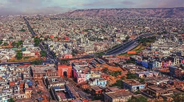
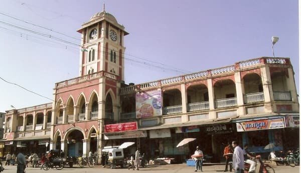
Rewa is an important regional city in north-eastern Madhya Pradesh and the administrative headquarters of Rewa district. It is also a major centre of the historic Baghelkhand region, with government offices, universities, hospitals, markets and educational institutions serving a much wider area beyond the municipal limits. The city’s identity combines its former princely-state heritage with a modern role as a service and transport hub for eastern Madhya Pradesh.
Rewa sits on the road corridor linking the Satna-Jabalpur side of Madhya Pradesh with Prayagraj and eastern Uttar Pradesh, while another major route continues toward Sidhi and Singrauli. Rewa Railway Station connects with Satna and the wider national rail network. The city’s connectivity has improved further since Rewa Airport was inaugurated under the UDAN regional-connectivity programme, and scheduled passenger flights now provide a direct air option that was not available to the city in earlier years.

Quick About Rewa City Madhya Pradesh
| Detail | Information |
| State | Madhya Pradesh |
| Region | Baghelkhand |
| District | Rewa |
| City administration | Rewa Municipal Corporation |
| City character | Administrative, educational, healthcare and regional commercial centre |
| Main central PIN code | 486001 (Rewa H.O.) |
| Other important city PINs | 486002, 486003, 486004 and 486005 depending on locality/post office |
| Main railway station | Rewa Railway Station |
| Airport | Rewa Airport, Chorhata |
| Major road corridors | NH 30 and NH 39 |
| Nearby areas | Chorhata, Ratahara, Govindgarh, Bela, Mangawan, Satna-side corridor |
Where is Rewa City Located in Madhya Pradesh?
Rewa is located in the north-eastern part of Madhya Pradesh and is one of the principal cities of the Baghelkhand region. It serves as both the district headquarters and an important divisional centre for government administration, education and healthcare.
The city lies east of Satna and west of the Uttar Pradesh border region. Prayagraj is an important external urban reference to the north-east, while Satna provides a major rail and road connection to the west. The Sidhi-Singrauli corridor extends to the east and south-east.
Rewa’s built-up area includes the traditional central city as well as expanding neighbourhoods around Civil Lines, Sirmour Chowk, Ratahara, University Road, Bichhiya and Chorhata. For daily travel, the exact locality matters because the airport, university-side areas, railway station and highway approaches lie in different parts of the urban area.
Rewa City Layout and Main Urban Areas
- Central Rewa and Sirmour Chowk: A busy commercial and transport zone with markets, offices, hospitals and connections toward several major roads.
- Civil Lines: An important administrative and institutional area with government offices, residences and established urban services.
- University and Engineering College side: The eastern and south-eastern education belt includes Awadhesh Pratap Singh University and engineering-college areas with their own postal zones.
- Bichhiya and Ratahara: Growing residential neighbourhoods connected with central Rewa and outer road corridors.
- Chorhata: An important western-side locality because it contains Rewa Airport and provides access toward the Satna highway side.
Rewa remains more compact than India’s largest metropolitan cities, but recent road, airport and residential development has spread activity beyond the old centre. The most practical neighbourhood therefore depends on whether a resident needs frequent access to the railway station, airport, university, hospital district or a particular highway.
Rewa City PIN Code
India Post lists Rewa Head Post Office under PIN code 486001, which is the main central postal reference for the city. Several Rewa localities and post offices also use 486001, including Bichhiya Road, Chauhatta, Chirahula and Medical College addresses.
Rewa has multiple additional city PINs. Rewa Engineering College uses 486002, the APS University area uses 486003, Rewa City Sub Post Office uses 486004, and Bansagar Colony uses 486005.
For property registration, courier delivery, university records, bank KYC or government applications, residents should use the postal code attached to the exact locality rather than assuming that every Rewa address uses 486001.
Road Connectivity
NH 30
NH 30 is the main westbound highway corridor from Rewa toward Satna, Katni and Jabalpur and also forms part of a much larger national route. It is one of the most important roads for long-distance movement from the city.
NH 39
NH 39 connects the Rewa side toward Sidhi and Singrauli. NHAI records also show ongoing four-laning and bypass work on sections around Rewa, so travellers should distinguish completed highway stretches from sections still being upgraded.
Prayagraj and Eastern Uttar Pradesh Side
Road connections from Rewa toward Mangawan and the Uttar Pradesh border provide important access to Prayagraj and eastern Uttar Pradesh. This corridor is heavily used for regional business, education and family travel.
| Road/Route | Useful For |
| NH 30 | Satna, Katni, Jabalpur and western Madhya Pradesh connections |
| NH 39 | Sidhi, Singrauli and south-eastern regional travel |
| Prayagraj-side roads | Eastern Uttar Pradesh and inter-state movement |
| Chorhata road | Airport and western urban access |
| City arterial roads | Sirmour Chowk, Civil Lines, university and residential neighbourhoods |
Local Public Transport Connectivity
Rewa does not have a metro system. Local movement depends on city and regional buses, autos, e-rickshaws, taxis, two-wheelers and private vehicles.
Bus services are particularly important because Rewa acts as a regional centre for nearby towns and rural areas. Regular road transport links the city with Satna, Sidhi, Singrauli, Prayagraj and other destinations across the Vindhya and Baghelkhand region.
Autos and e-rickshaws are widely used for station, market, hospital and university trips. For visitors unfamiliar with the city, giving a major landmark such as Sirmour Chowk, Civil Lines, APS University, railway station or airport is usually more useful than giving only a neighbourhood name.
Bus, Rail and Airport Access
Rewa Railway Station is the city’s main rail gateway. The district administration states that Rewa is connected to Satna through the approximately 50 km Satna-Rewa branch line, which gives the city onward access to the broader West Central Railway network.
Road buses remain important for routes where rail is indirect, particularly toward Sidhi, Singrauli and many district towns. Intercity buses also provide frequent connections toward Satna and neighbouring regions.
Rewa Airport at Chorhata was inaugurated in October 2024 under the Regional Connectivity Scheme. By 2026 it had developed scheduled passenger connectivity, including direct Delhi services and regional routes. Flight frequencies and destinations can change, so passengers should confirm the date-specific airline timetable before travel.
Nearby Areas Around Rewa City
- Chorhata: The airport-side locality west of central Rewa and an important road approach from the Satna direction.
- Ratahara: A developing residential area connected with the southern and south-eastern parts of the city.
- Govindgarh: A nearby town known for its historic and natural surroundings and linked with Rewa by road.
- Bela: A highway-side reference point west of Rewa near the NH 30 and bypass connections.
- Mangawan: An important town on the Rewa-Prayagraj side and a common road reference for travel toward Uttar Pradesh.
- Satna: The nearest major rail and commercial city to the west and an important onward transport connection for Rewa.
FAQs
Q. Is Rewa a municipal city?
Yes. Rewa is governed by Rewa Municipal Corporation and is the headquarters of Rewa district in Madhya Pradesh.
Q. Does Rewa have its own airport?
Yes. Rewa Airport at Chorhata was inaugurated in 2024 and now handles scheduled passenger flights. Travellers should check current airline schedules because routes and frequencies can change.
Q. Which PIN code is the main one for Rewa?
Rewa Head Post Office uses 486001, but the city has several other postal codes including 486002, 486003, 486004 and 486005.
Q. Does Rewa have a metro?
No. Local transport is mainly by bus, auto, e-rickshaw, taxi and private vehicle.
Q. How is Rewa connected by rail?
Rewa Railway Station is linked to Satna through the Satna-Rewa branch line, giving passengers onward connections to the wider national railway network.
Q. Which areas are useful for transport access in Rewa?
Central Rewa and Sirmour Chowk are useful for city movement, Chorhata is convenient for the airport and Satna-side highway, while the university and Civil Lines areas are practical for education and government services.