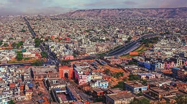
Jaipur is globally known as the Pink City, but the name is most closely associated with its historic walled core – the part of the capital where terracotta-pink facades, ceremonial gates, broad bazaars and landmark buildings such as Hawa Mahal, City Palace and Jantar Mantar define the streetscape. The old city was laid out in the eighteenth century as a planned urban centre, and its grid of markets and public squares remains central to Jaipur’s identity today.
The Pink City is not only a heritage zone. It is also a working commercial district with jewellery markets, textile shops, temples, wholesale businesses, homes and busy local streets. Metro stations at Chandpole, Chhoti Chaupar and Badi Chaupar have made the old city easier to reach without taking a car into its most congested lanes.
Quick About Jaipur Pink City
| Detail | Information |
| City | Jaipur, Rajasthan |
| Historic core | Walled City / old Jaipur |
| Founded | 1727 |
| Known for | Pink facades, bazaars, palaces and heritage streets |
| Common heritage-core PIN | 302002; adjoining old-city zones use other Jaipur PINs |
| Metro line | Jaipur Metro Pink Line |
| Key metro stations | Chandpole, Chhoti Chaupar, Badi Chaupar |
| Major landmarks | Hawa Mahal, City Palace, Jantar Mantar, Johari Bazaar |
| Nearby areas | C-Scheme, Bani Park, Adarsh Nagar, Raja Park, Amer Road |
Where is the Pink City Located in Jaipur?
The historic Pink City occupies the central walled area of Jaipur. It is organised around old gates, bazaars and public squares such as Badi Chaupar and Chhoti Chaupar. Hawa Mahal, City Palace and Jantar Mantar lie within this central heritage cluster.
Modern Jaipur has expanded far beyond the original walls, so ‘Pink City’ is sometimes used as a nickname for the entire city. For location planning, however, the term is most useful when referring to the walled old city around Johari Bazaar, Tripolia Bazaar, Kishanpole and the palace precinct.
The old city is compact in map terms but can be slow to cross by car because of market traffic, pedestrians, two-wheelers and narrow side lanes. Metro, walking and short auto rides are often more practical for heritage visits.
Historic Walled City Layout
- Chaupars: Badi Chaupar and Chhoti Chaupar are major historic squares and useful navigation points inside the old city.
- Bazaar streets: Johari Bazaar, Tripolia Bazaar, Kishanpole Bazaar and adjoining market streets form the commercial spine of the heritage core.
- Palace precinct: City Palace, Jantar Mantar and Hawa Mahal sit close together on the eastern-central side of the walled city.
- Historic gates: Chandpole, Ajmeri Gate, Sanganeri Gate and other gateways connect the old city with modern Jaipur roads.
The planned grid makes the old city easy to understand on a map, but real travel time depends on market activity and pedestrian traffic. Visitors should avoid treating every heritage landmark as a car-friendly stop.
Jaipur Pink City PIN Code
The Pink City does not have one universal PIN code because the walled area spans several postal zones. PIN 302002 is commonly used for the Hawa Mahal, Badi Chaupar, Amer Road and Tripolia Bazaar side of the heritage core.
Other old-city areas can use 302001 or 302003, among additional Jaipur postal codes. This is why two landmarks within the broader Pink City can show different PINs despite being relatively close.
For hotels, shops, courier deliveries or official correspondence, use the exact street and post office code instead of writing only ‘Pink City, Jaipur’.
Road Connectivity
MI Road and Chandpole Side
MI Road provides an important approach from modern central Jaipur toward Chandpole and the western edge of the walled city. It also links toward the railway station and C-Scheme side.
Amer Road and Delhi Road Side
The northern and northeastern approach connects the old city toward Jal Mahal, Amer and Delhi Road. This is useful for visitors combining Pink City landmarks with Amer Fort.
Ajmeri Gate and Sanganeri Gate Side
Southern gateways connect the heritage core with Tonk Road-side neighbourhoods, Raja Park, Adarsh Nagar and other modern parts of Jaipur.
| Road/Route | Useful For |
| MI Road / Chandpole | Railway station, C-Scheme and western Jaipur |
| Amer Road | Jal Mahal, Amer and northern Jaipur |
| Ajmeri Gate side | Central and southern Jaipur access |
| Sanganeri Gate side | Raja Park, Adarsh Nagar and Tonk Road directions |
| Old-city bazaar roads | Local movement between heritage markets and landmarks |
Metro Connectivity
Jaipur Metro’s Pink Line runs directly through the historic city. Chandpole sits at the western edge of the old city, while Chhoti Chaupar and Badi Chaupar are underground stations inside the heritage area.
Badi Chaupar is particularly convenient for Hawa Mahal, City Palace, Jantar Mantar and Johari Bazaar. This allows visitors to leave a car outside the busiest heritage streets and complete the final part of the trip on foot.
The same line also serves Jaipur Railway Station and Sindhi Camp, making it useful for travellers arriving by train or intercity bus.
Bus, Rail and Airport Access
Sindhi Camp is Jaipur’s main intercity bus hub and is connected with the Pink Line. City buses, autos, e-rickshaws and app cabs also serve the approaches to the old city.
Jaipur Junction is the main railway station and has its own metro stop on the Pink Line. This creates a direct rail-to-metro link for visitors heading to Chandpole or Badi Chaupar.
Jaipur International Airport is in the southern part of the city. There is no direct metro link from the airport to the Pink City at present, so road transport is required for the airport leg.
Nearby Areas Around Jaipur Pink City
- C-Scheme: A central modern commercial and residential district southwest of the walled city.
- Bani Park: A well-established neighbourhood near Jaipur Junction and the northern-central city.
- Adarsh Nagar: A residential and commercial area east of the old city with quick access through the heritage gates.
- Raja Park: A busy shopping and residential locality southeast of the Pink City.
- Amer Road: The northern corridor toward Jal Mahal and Amer Fort.
- Civil Lines: An established western-central neighbourhood accessible through the metro and major city roads.
FAQs
Q. Does Pink City mean the whole of Jaipur?
Jaipur is widely nicknamed the Pink City, but the historic meaning is strongest for the walled old city with its pink facades, bazaars and palace landmarks.
Q. Which metro station is best for Hawa Mahal?
Badi Chaupar is the most convenient Pink Line station for Hawa Mahal and also works well for City Palace and Jantar Mantar.
Q. Is Amer Fort inside the Pink City?
No. Amer Fort is north of the walled city. It is usually reached by road via Amer Road.
Q. Why do different Pink City addresses show different PIN codes?
The heritage area spans more than one postal zone. 302002 is common around Hawa Mahal and Badi Chaupar, but other old-city streets use different Jaipur PINs.
Q. Is driving the easiest way to see the old city?
Not always. Market congestion and limited parking can make metro plus walking or short auto rides more practical.
Q. Can Jaipur Junction be reached directly by metro from the old city?
Yes. The Pink Line connects Badi Chaupar, Chhoti Chaupar and Chandpole with the Railway Station stop.