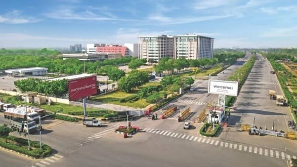
Mahindra World City Jaipur is a large integrated business city on the western side of Jaipur, developed through a partnership between Mahindra Lifespaces and RIICO. The project combines a multi-sector Special Economic Zone, Domestic Tariff Area and supporting social infrastructure within a planned industrial and business environment. It is designed primarily for companies, manufacturing, technology and service operations rather than as a conventional city-centre residential neighbourhood.
The development is located off NH 48 in Sanganer tehsil and forms part of Jaipur’s western industrial growth corridor. Its road connection to Ajmer Road, proximity to the Jaipur Ring Road and access to the airport and railway network make it useful for businesses that need movement of employees, goods and visitors without operating from the crowded central city.
Quick About Mahindra World City Jaipur
| Detail | Information |
| City | Jaipur, Rajasthan |
| Location | Sanganer tehsil, western Jaipur |
| Development type | Integrated business city / SEZ and DTA |
| Approximate total area | About 3,000 acres |
| Main PIN code | 302037 |
| Main road | NH 48 / Ajmer Road corridor |
| Airport distance | About 22 km from Jaipur International Airport |
| Rail reference | About 21 km from Jaipur Railway Station |
| Nearby areas | Kalwara, Bagru Khurd, Jhai, Bhambhoriya, Newta |
Where is Mahindra World City Jaipur Located?
Mahindra World City Jaipur is located in Sanganer tehsil on the western edge of Jaipur, off the NH 48/Ajmer Road corridor. Government SEZ records identify villages including Kalwara, Jhai, Bhambhoriya, Bagru Khurd and Newta in the broader notified location.
The site is outside Jaipur’s dense central business districts. That is useful for large industrial campuses and logistics movement, but employees and visitors usually need road transport for the final journey from central Jaipur, the railway station or the airport.
The development also lies within the influence zone of the Delhi-Mumbai Industrial Corridor. For businesses, this regional position is as important as local city access because it supports long-distance industrial and freight connectivity.
Business Zones and City Layout
- Special Economic Zone: A major portion of the development is planned as a multi-sector SEZ for export-oriented and technology-linked businesses.
- Domestic Tariff Area: The DTA supports companies operating for the domestic market outside the SEZ framework.
- Social and support infrastructure: The larger plan includes facilities intended to support employees, business services and the long-term city ecosystem.
- Planned internal infrastructure: Wide internal roads, utilities, green areas and managed services are part of the business-city model.
The exact destination matters because Mahindra World City Jaipur covers a very large land area. Visitors should use the company, gate, zone or plot number rather than only the township name.
Mahindra World City Jaipur PIN Code
Mahindra World City Jaipur has a dedicated India Post entry with PIN code 302037. Mahindra Lifespaces also uses this PIN in its official contact address for the Jaipur development.
This dedicated postal identity is useful for companies and offices inside the business city, but nearby Kalwara, Bagru and other villages may use different postal codes.
For courier, legal and company documents, the correct format should include the company or plot, Mahindra World City, Sanganer tehsil, Jaipur, Rajasthan and PIN 302037.
Road Connectivity
NH 48 / Ajmer Road Corridor
Mahindra World City is located off NH 48, giving it direct access to Jaipur’s western approach and the important Jaipur-Ajmer road corridor.
Jaipur Ring Road
Proximity to the Ring Road improves orbital movement around Jaipur and can reduce the need to pass through the city centre for some industrial and airport-side journeys.
Delhi-Mumbai Industrial Corridor Influence Zone
The project’s wider location supports industrial connectivity toward the Rajasthan-Gujarat-Maharashtra corridor and strengthens its logistics role beyond Jaipur.
| Road/Route | Useful For |
| NH 48 / Ajmer Road | Central Jaipur, Ajmer side and regional highway movement |
| Jaipur Ring Road | Orbital access around the city |
| Internal industrial roads | Company campuses, SEZ and DTA plots |
| Kalwara/nearby village roads | Local workforce and surrounding-area access |
| Regional freight corridors | Industrial movement toward wider Rajasthan and western India |
Metro and Public Transport Connectivity
Mahindra World City Jaipur does not have an operational Jaipur Metro station inside the development. Employee movement therefore depends mainly on company transport, buses, cabs, two-wheelers and private vehicles.
Jaipur Metro is useful within the urban core, but it does not currently provide a direct last-mile connection to Mahindra World City. A road transfer is required from any metro station.
For companies with large workforces, organised staff buses and shift transport are especially important because the business city is outside dense central residential areas.
Bus, Rail and Airport Access
Mahindra Lifespaces places Jaipur International Airport at about 22 km from the development. This is a useful advantage for corporate visitors, although actual travel time varies with Ring Road and city traffic.
Jaipur Railway Station is listed at about 21 km, while an inland container depot is also located within regional reach. These links are particularly relevant for industrial and business operations.
Local bus and cab availability is improving with development around Ajmer Road, but visitors to a specific company should still confirm gate access and return transport, especially outside normal office hours.
Nearby Areas Around Mahindra World City Jaipur
- Kalwara: A key local village associated with the Mahindra World City address and adjoining development.
- Bagru Khurd: One of the villages identified in the wider SEZ location on Jaipur’s western side.
- Jhai: A nearby village included in the broader Mahindra World City development area.
- Bhambhoriya: Part of the surrounding Sanganer tehsil landscape connected with the notified SEZ area.
- Newta: A nearby village in the western Jaipur growth corridor.
- Ajmer Road / NH 48 belt: The main urban and highway corridor connecting the business city with Jaipur and regional destinations.
FAQs
Q. Is Mahindra World City Jaipur the same as Mahindra World City Chennai?
No. They are separate integrated business cities developed in different states. This article covers the Jaipur project in Rajasthan.
Q. Is Mahindra World City Jaipur mainly residential?
No. Its core identity is an integrated business and industrial city with SEZ and Domestic Tariff Area components, although supporting social and residential infrastructure forms part of the wider ecosystem.
Q. Does Mahindra World City have a Jaipur Metro station?
No direct operational metro station is inside the development. Road-based employee and visitor transport remains essential.
Q. Which highway serves Mahindra World City Jaipur?
The development is located off NH 48 on the Ajmer Road side of Jaipur.
Q. Does the project have its own PIN code?
India Post lists Mahindra World City under PIN 302037, which is also used in the developer’s official Jaipur contact address.
Q. What should a visitor confirm before going there?
Confirm the company name, zone, plot or gate and return transport. The development covers thousands of acres, so a general Mahindra World City destination is not precise enough.