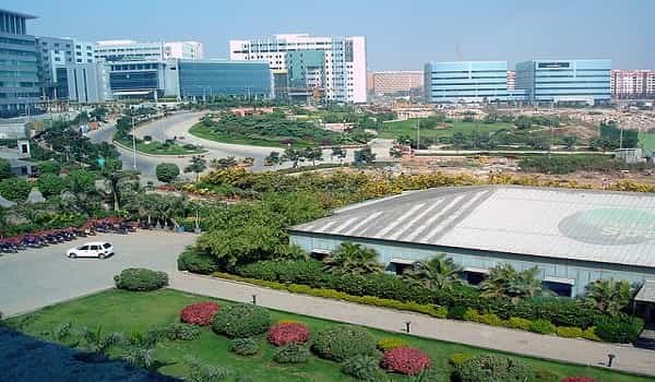
Electronic City is one of South Bengaluru’s best-known employment districts and has grown far beyond its original identity as an office and industrial hub. Large technology campuses now sit alongside apartment communities, schools, hospitals, shops and everyday services, making the area a practical residential choice for people who work along the Hosur Road corridor. The official township commonly uses the name “Electronics City,” while “Electronic City” is widely used in searches and addresses.
Connectivity is the area’s strongest advantage. Hosur Road/NH 44 forms the main road spine, the elevated expressway improves access from the Silk Board side, NICE Road links the locality with western and southern Bengaluru, and Namma Metro’s Yellow Line provides a direct rail option through the corridor. The main postal code for Electronic City is 560100.
Quick About Electronic City Bengaluru
| Detail | Information |
| City | Bengaluru, Karnataka |
| Part of Bengaluru | South Bengaluru |
| Main corridor | Hosur Road / NH 44 |
| Main PIN code | 560100 |
| Local character | IT, electronics and residential hub |
| Main parts | Phase I / West Phase and Phase II / East Phase |
| Metro line | Namma Metro Yellow Line |
| Key metro stations | Electronic City and Infosys Foundation Konappana Agrahara |
| Important road links | Hosur Road, Elevated Expressway, NICE Road |
| Nearby areas | Hosa Road, Singasandra, Begur, Bommasandra, Hebbagodi, Chandapura, Jigani |
Where is Electronic City Located in Bengaluru?
Electronic City lies on the Bengaluru-Hosur highway corridor in the southern part of the city. The core industrial township covers about 903 acres and was developed as a planned technology and electronics district.
In practical terms, the locality stretches around Konappana Agrahara, the major Electronic City campuses and the Hosur Road belt toward Bommasandra. People also use “Electronic City” for a much wider residential catchment than the formal township.
This distinction is important while checking a property address. Apartments marketed as being in or near Electronic City may actually be in Neeladri Road, Doddathogur, Shikaripalya, Gollahalli, Hebbagodi or Bommasandra. Their PIN code, civic authority and access road can therefore differ from the core township.
Electronic City Phases and Local Layout
- Phase I / West Phase: The older and more established section, with major corporate campuses, offices and access toward Konappana Agrahara and Neeladri Road.
- Phase II / East Phase: Extends around the other side of Hosur Road and includes technology, industrial and residential pockets.
The surrounding residential belt is equally important. Neeladri Road, Doddathogur, Shikaripalya and nearby layouts support a large working population. For commuters, the exact phase matters because Electronic City is too broad to estimate travel time from the locality name alone.
Electronic City Bengaluru PIN Code
The main PIN code for Electronic City is 560100. India Post lists Electronics City under this postal code.
However, every property marketed with the Electronic City name does not necessarily use 560100. Nearby localities can have different PIN codes. Bommasandra Industrial Estate, for example, uses 560099.
For property documents, bank KYC, courier delivery, school records or utility connections, use the exact postal address of the building rather than only the broader locality name.
Road Connectivity
Hosur Road / NH 44
Hosur Road is the principal north-south route through the area. It connects Electronic City with Silk Board, Bommanahalli and other parts of South Bengaluru to the north, while continuing toward Bommasandra, Attibele and Hosur to the south.
Electronic City Elevated Expressway
The elevated road between the Silk Board side and Electronic City separates much of the through traffic from the busy surface road. It is useful for car and cab commuters, although total journey time still depends on congestion before entering or after leaving the elevated stretch.
NICE Road
NICE Road provides an important orbital connection toward Bannerghatta Road, Kanakapura Road, Mysuru Road and western Bengaluru. It is especially useful when the destination is outside the central city.
| Road/Route | Useful For |
| Hosur Road / NH 44 | Silk Board, Bommanahalli, Bommasandra, Attibele, Hosur |
| Elevated Expressway | Faster movement toward the Silk Board side |
| NICE Road | Bannerghatta Road, Kanakapura Road, Mysuru Road, western Bengaluru |
| Hosa Road link | Hosa Road and Sarjapur Road-side movement |
| Neeladri Road | Residential pockets adjoining Phase I |
Metro Connectivity
Namma Metro’s Yellow Line has significantly improved public transport in Electronic City. The elevated line runs between RV Road and the Bommasandra end of the Hosur Road corridor.
The area is directly served by stations including Electronic City and Infosys Foundation Konappana Agrahara. The line is useful for travel toward Silk Board, BTM Layout, Jayadeva and RV Road, with interchange possibilities to the wider Namma Metro network.
Last-mile planning still matters. Electronic City has large campuses and spread-out residential pockets, so some commuters may need an auto, feeder bus, shuttle, two-wheeler or short cab ride between the station and their final destination.
Bus, Rail and Airport Access
BMTC buses remain important because they connect office gates, residential pockets and destinations that are not directly beside a metro station. Employer shuttle services are also common in the technology corridor.
Heelalige is among the closer railway points on the southeastern side of Bengaluru. For long-distance trains, residents may also use larger Bengaluru terminals, depending on the route.
Kempegowda International Airport is in North Bengaluru, so airport travel from Electronic City is a long cross-city journey. Cabs and airport buses are common choices, and travellers should keep a generous time buffer during weekday traffic.
Nearby Areas Around Electronic City
- Hosa Road: Convenient for movement toward Sarjapur Road and nearby southeastern residential areas.
- Singasandra: Located toward the city side of Hosur Road and useful for commuters who prefer to stay north of Electronic City.
- Begur: A large residential belt with links toward Bommanahalli and Bannerghatta Road.
- Bommasandra: A major industrial and residential zone immediately south of Electronic City and part of the Yellow Line corridor.
- Hebbagodi: Close to Bommasandra, with a strong mix of industrial and residential development.
- Chandapura: Farther south on Hosur Road and known for larger residential developments and access toward Anekal.
- Jigani: An industrial-residential belt to the southwest, connected toward Bannerghatta and Anekal.
- Neeladri Road and Doddathogur: Among the most closely linked residential pockets for people working in Phase I.
FAQs
Q. Is Electronic City suitable for someone working on Hosur Road but outside the tech parks?
Yes, it can be convenient because Hosur Road, the elevated expressway and Yellow Line provide different travel options. The best micro-location depends on whether the workplace is north toward Bommanahalli or south toward Bommasandra and Attibele.
Q. Which part of Electronic City is better for regular metro users?
A home with a simple feeder route to Electronic City or Infosys Foundation Konappana Agrahara station is generally more practical. A project can carry the Electronic City name but still be several kilometres from a station.
Q. Is Electronic City convenient for commuting to Whitefield?
It is possible, but it is a cross-city commute. The full door-to-door route and interchange time matter more than straight-line distance.
Q. Are all Electronic City apartments under ELCITA?
No. ELCITA governs the notified industrial township area, while many nearby residential layouts and apartment projects lie outside that boundary. Civic services and property-related authorities can differ by exact location.
Q. Is a home near NICE Road automatically convenient for central Bengaluru?
Not always. NICE Road is excellent for orbital movement toward western and southern corridors, but central Bengaluru access still depends on the nearest interchange and surface-road traffic.
Q. What should tenants check before choosing between Phase I and Phase II?
Check the exact office gate, metro access, peak-hour last-mile route, daily shopping and school access, and whether the commute requires frequently crossing Hosur Road.